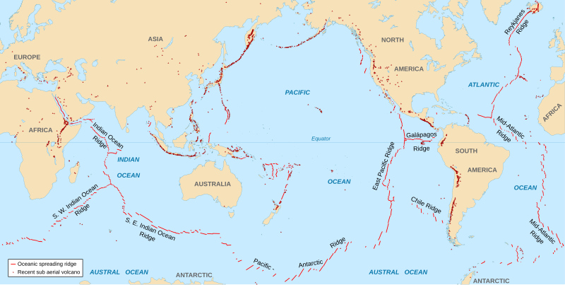
Ngokweenkcukacha:Spreading ridges volcanoes map-en.svg
Appearance

Size of this PNG preview of this SVG file: 800 × 402 pixels. Other resolutions: 320 × 161 pixels | 640 × 322 pixels | 1 024 × 515 pixels | 1 280 × 643 pixels | 2 560 × 1 286 pixels | 4 995 × 2 510 pixels.
Original file (SVG file, nominally 4 995 × 2 510 pixels, file size: 1.29 MB)
File history
Click on a date/time to view the file as it appeared at that time.
| Umhla/ixesha | Thumbnail | Dimensions | User | Khawuphawule | |
|---|---|---|---|---|---|
| Ngoku | 18:51, 6 Eyo Msintsi 2015 |  | 4 995 × 2 510 (1.29 MB) | Sting | New background map using NGDC WCL data |
| 12:58, 11 Eye Nkanga 2007 |  | 5 000 × 2 525 (913 KB) | Walké | petite correction | |
| 22:10, 23 Eye Dwarha 2006 |  | 5 000 × 2 525 (913 KB) | Sting | OCR name correction; + Red Sea OCR; + continent names | |
| 15:25, 23 Eye Dwarha 2006 |  | 5 000 × 2 525 (898 KB) | Sting | {{Information| |Description=World map in English showing the divergent plate boundaries (OSR – Oceanic Spreading Ridges) and recent sub aerial volcanoes |Source= '''Background map (modified) :''' Image:Tectonic plates (empty).svg created by [[User: |
Ukusetyenziswa kwale file
The following page uses this file:
Global file usage
The following other wikis use this file:
- Usage on af.wikipedia.org
- Usage on as.wikipedia.org
- Usage on en.wikipedia.org
- Usage on en.wikiquote.org
- Usage on fi.wikipedia.org
- Usage on fr.wikipedia.org
- Usage on gu.wikipedia.org
- Usage on it.wikibooks.org
- Usage on ja.wikipedia.org
- Usage on ki.wikipedia.org
- Usage on lij.wikipedia.org
- Usage on mk.wikipedia.org
- Usage on ml.wikipedia.org
- Usage on mwl.wikipedia.org
- Usage on pnb.wikipedia.org
- Usage on pt.wikipedia.org
- Usage on rm.wikipedia.org
- Usage on sr.wikipedia.org
- Usage on ta.wikipedia.org
- Usage on te.wikipedia.org
- Usage on tl.wikipedia.org
- Usage on tr.wikipedia.org
- Usage on tt.wikipedia.org
- Usage on tyv.wikipedia.org
- Usage on ur.wikipedia.org
- Usage on vi.wikipedia.org

