
File:Cape Town 2011 population density map.svg

Size of this PNG preview of this SVG file: 405 × 599 pixels. Other resolutions: 162 × 240 pixels | 324 × 480 pixels | 519 × 768 pixels | 692 × 1 024 pixels | 1 385 × 2 048 pixels | 771 × 1 140 pixels.
Original file (SVG file, nominally 771 × 1 140 pixels, file size: 761 KB)
Isishwankathelo
| Inkcazo |
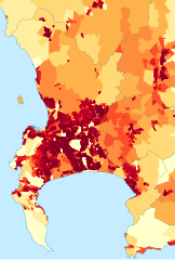
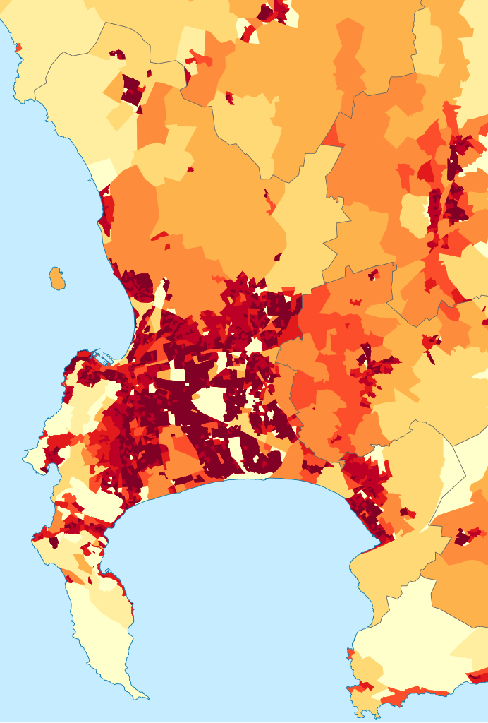
English: Population density map of the City of Cape Town, Western Cape, South Africa, from the 2011 Census, at the "Small Area" level.
<1 inhabitant/km²
1–3 inhabitants/km²
3–10 inhabitants/km²
10–30 inhabitants/km²
30–100 inhabitants/km²
100–300 inhabitants/km²
300–1000 inhabitants/km²
1000–3000 inhabitants/km²
>3000 inhabitants/km² |
| Umhla | |
| Imvelaphi | Statistics South Africa's Census 2011 is the source of the basic population data. The map results from my own processing of the data. |
| Umbhali | Htonl |
| Permission (Reusing this file) |
http://beta2.statssa.gov.za/?page_id=425 |
ukunika imvume
The following license applies to the population data on which the map is based:
 |
The copyright holder of this file allows anyone to use it
for any purpose, provided that the user acknowledges Stats SA as the source of the basic data wherever they process, apply, utilise, publish or distribute the data, and also that they specify that the relevant application and analysis (where applicable) result from their own processing of the data..
Usage notes:
|
|
Please check that the conditions given above are compliant to the Commons licensing policy. Most importantly, derivative work and commercial use must be allowed.
|
The following tag applies to the map itself:
| I, the copyright holder of this work, release this work into the public domain. This applies worldwide. In some countries this may not be legally possible; if so: I grant anyone the right to use this work for any purpose, without any conditions, unless such conditions are required by law. |
File history
Click on a date/time to view the file as it appeared at that time.
| Umhla/ixesha | Thumbnail | Dimensions | User | Khawuphawule | |
|---|---|---|---|---|---|
| Ngoku | 18:05, 26 Eyo Msintsi 2015 | | 771 × 1 140 (761 KB) | Htonl | style/size tweak |
| 14:25, 13 Eye Dwarha 2013 |  | 718 × 1 045 (505 KB) | Htonl | == {{int:filedesc}} == {{Information |Description={{en|1=Population density map of the City of Cape Town, Western Cape, South Africa, from the 2011 Census, at the "Small Area" level. {{legend|#ffffcc|<1 inhabitant/km²}} {{legend|#ffeda0|1–3 inhab... |
Ukusetyenziswa kwale file
The following page uses this file:
Global file usage
The following other wikis use this file:
- Usage on be.wikipedia.org
- Usage on de.wikipedia.org
- Usage on en.wikipedia.org
- Usage on gl.wikipedia.org
- Usage on gu.wikipedia.org
- Usage on he.wikipedia.org
- Usage on hu.wikipedia.org
- Usage on hy.wikipedia.org
- Usage on ja.wikipedia.org
- Usage on ka.wikipedia.org
- Usage on ko.wikipedia.org
- Usage on mk.wikipedia.org
- Usage on nso.wikipedia.org
- Usage on pt.wikipedia.org
- Usage on ro.wikipedia.org
- Usage on sw.wikipedia.org
- Usage on uk.wikipedia.org